
Aim
The aim of this guide is to provide guidance on the use of signage to manage public access and to provide templates for signage that have been approved by the stalking sub-group of the National Access Forum1.
Introduction
- Public access to Scotland’s outdoors is an established legal right that carries responsibilities both for land managers and access takers .
- Managing access is often best conducted via the use of signage. Alternative mechanisms are described later in this guidance. It is important for legal reasons and to encourage people to follow requests that signs are well worded, designed and properly sited.
Sign wording
- It is important to note that signs MUST NOT be used to deter people from exercising their access rights. Signs stating things like “Danger – high velocity rifles in use”, could be construed as an attempt to prevent access and might be considered as not complying with access legislation and unlikely to be complied with. Signs which give specific information relating to short time periods and which still allow access takers to reach their objectives are more likely to be positively received.
- Signs do not need to be expensive and often an obviously homemade sign which can be readily updated and looks like it carries relevant, recent information is more likely to be successful. Signs with fixed text may be left in place all year or for a particular season, but they will need to be worded in a very general manner and will therefore possibly have less of an impact on those reading them.
Position of Signs
- Hills and woodlands/forests can be approached from many directions. Most people will follow recognised routes and a sign can often be easily placed at the start of these routes and/or in car parks. It is important that signs are in position before people become too committed to a particular route.
Content of Signs
- There are several points to consider when creating signs:
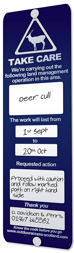
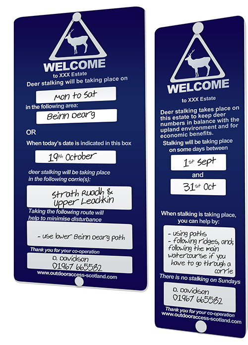
- Requests to avoid particular areas should relate to specific days and times where applicable as indicated in the Access Code.
- Requests should apply to the minimum necessary area. In the case of upland areas, this will normally be the corrie or corries in which stalking is taking place, with the presumption that access can continue along adjacent ridges.
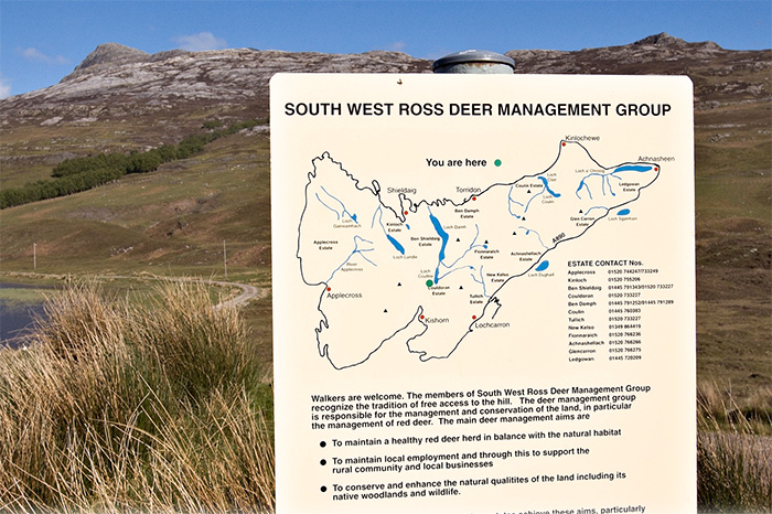
- It may be helpful to include a map on the sign to illustrate the area more clearly (even if this is only a simple sketch map).
- Requests should include suggested alternative routes of a similar nature which will not interfere with stalking.
- All signs relating to stalking should request co-operation using polite, friendly and reasonable language, and a directive or officious tone will almost certainly be counter productive.
Alternatives to Signs
Many estates already participate in the Hillphones scheme which gives advance notification to walkers and climbers of stalking intentions. This builds on the principle that the sooner people can take stalking activity into account, the less disruption there is likely to be.
A new online version of Heading for the Scottish Hills is to be produced, allowing estates to update information on a daily basis, or to provide longer term information and contact details. It is hoped that this will become a major resource for those planning to go walking or climbing and is likely to be a major route of communication between stalkers and walkers.
Sign Templates
Circumstances vary considerably between estates and no one form of words will necessarily suit all situations. The two examples shown were developed by the National Access Forum stalking sub-group to be suitable for a wide range of situations.
Recognised routes
Much can be undertaken to assist access takers to reduce their unintentional impacts. Although access can be taken anywhere, often the recognised routes are not clearly signposted.
If the established or preferred route is clearly marked many access takers will willingly follow that route, especially if junctions, unexpected changes of direction or deviations occur. Care must be taken to ensure that the route marked is the exact route recorded.
A little effort to make the recognised routes easily passable will also lead to more people staying on that route. Tracks, fords, styles, gates and paths that are on the preferred route will be used if they are fit for purpose. Eroded, broken or dysfunctional access routes will lead to straying, climbing or detouring which will cause disturbance, nuisance, increased cost and risk of damage or injury.